Karenko Prefectural Government Office Site
花蓮港庁舎跡
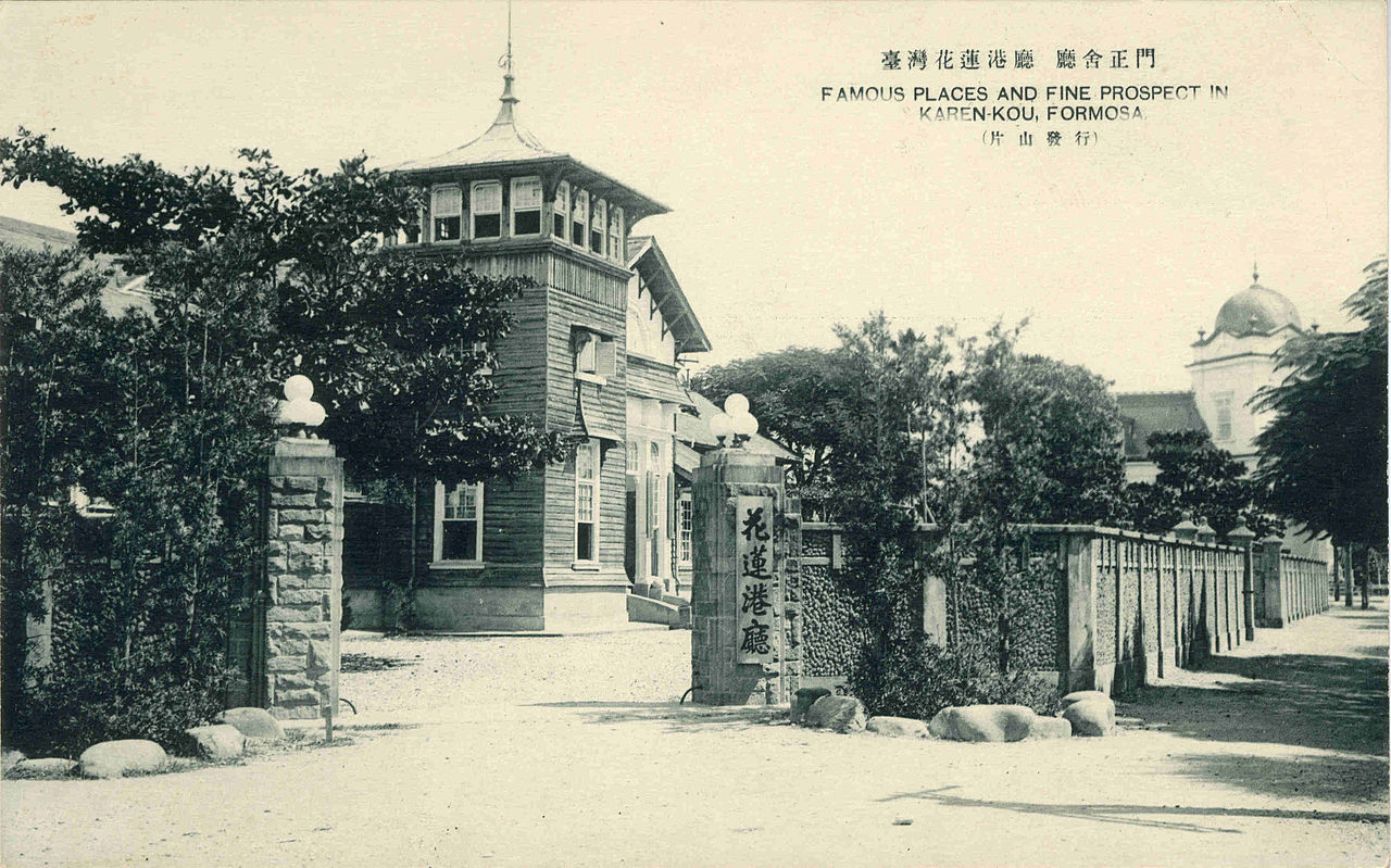
The Karenko (花蓮港) Prefectural Government Office was the highest administrative authority for the Hualien area of eastern Taiwan during the Japanese colonial period. Established in 1909 when Taiwan was reorganized from twenty to twelve prefectures, the office oversaw a vast mountainous territory corresponding to present-day Hualien County; Taitung remained a separate prefecture. The original wooden building was destroyed by fire in 1910 and rebuilt as a Japanese-Western hybrid structure. A modernist concrete building replaced it around 1936. After Japan's surrender in 1945, the building served as the Hualien County Government headquarters until earthquake damage forced relocation to the current Meilun district site.
Images


History
The Karenko Prefectural Government Office (花蓮港庁, Karenkō Chō) was established on October 25, 1909, when the Japanese colonial government reorganized Taiwan's administrative divisions from twenty prefectures to twelve. The new prefecture was formed from the Karenko and Hakusekikaku (璞石閣, later Tamazato/Yuli) branch offices that had previously operated under Taito Prefecture (台東庁) since 1901. As the administrative authority for the northern half of eastern Taiwan, the office governed a vast and rugged territory stretching from the Pacific coast to the Central Mountain Range.
The first prefectural office building was a modest wooden structure located in the Karenko township (present-day downtown Hualien City, near the intersection of Zhongshan Road and Gongyuan Road). When it was destroyed by fire in 1910, the first prefectural governor, Ishibashi Toru (石橋亨), oversaw its reconstruction as a Japanese-Western hybrid (和洋折衷) wooden building. During the 1930s, as the colonial government modernized its administrative infrastructure across Taiwan, the office was rebuilt as a reinforced concrete structure in the modernist architectural style typical of late colonial government buildings, completed around 1936.
Throughout its existence, the Karenko Prefectural Office administered the development of eastern Taiwan's infrastructure, including railways, roads, harbors, and agricultural settlements. The office also oversaw the controversial "barbarian management" (理蕃) policies directed at Taiwan's indigenous peoples, particularly the Truku, Amis, and Bunun communities. Under the prefecture's jurisdiction, Japanese colonizers established camphor extraction operations, sugarcane plantations, and timber harvesting enterprises. On October 1, 1937, the prefecture implemented the street-township system (街庄制), and on October 28, 1940 Karenko was elevated to city status.
During World War II, the Karenko Prefecture played a strategic role in eastern Taiwan's defense preparations. The region's relative isolation made it a secondary target for Allied bombing, though Hualien Harbor and nearby military installations did come under attack. The prefecture managed civil defense, resource mobilization, and the conscription of local Taiwanese and indigenous men for military service and labor battalions.
Following Japan's surrender on August 15, 1945, the Republic of China government reformed the prefecture into Hualien County (花蓮縣) in 1946. The former prefectural office building continued to serve as the Hualien County Government headquarters. However, the building sustained significant damage from earthquakes — eastern Taiwan lies along the active Philippine Sea Plate boundary — and the county government eventually relocated to its current site in the Meilun (美崙) district. The original prefectural office site in downtown Hualien was redeveloped as a commercial area, now occupied by the Fuxing Market (復興市場) and surrounding shops. While no original structures remain at the site, the location holds enduring historical significance as the nerve center of Japanese colonial administration in eastern Taiwan for over three decades.
Categories
Related themes
Sources
- 花蓮港廳 — Wikipedia (zh)Website