
1931 — 1945
World War II
Japan Historical Atlas
Wartime Japan, put back on the map: naval ports, factories, headquarters, air-raid and atomic-bomb sites — and the memorials you can still visit today.
Background: Hiroshima Peace Memorial (Atomic Bomb Dome), Wikimedia Commons
Explore by region
The atlas centres on the Japanese home islands and also covers Taiwan, Korea and Manchuria, which Japan ruled or controlled at the time.
This month in history: October
All events →Featured national sites
View all →
Former Ministry of Foreign Affairs Building
外務省旧庁舎
The Ministry of Foreign Affairs at Kasumigaseki, Chiyoda Ward, Tokyo, was the nerve center of Japanese wartime diplomacy. The original Western-style building designed by French architect Boinville was completed in 1881 but destroyed in the 1923 Great Kanto Earthquake. The rebuilt ministry served as the site where the Potsdam Declaration was received, translated, and deliberated upon in July–August 1945, and where the Instrument of Surrender was prepared. Foreign Minister Mamoru Shigemitsu departed from this building on September 2, 1945 to sign the surrender aboard USS Missouri. The wartime building was destroyed in the May 25, 1945 air raids on Tokyo. The current complex (North Building 1960, Central/South Buildings 1970) designed by Hideo Kosaka occupies the same Kasumigaseki site.

Chiran Peace Museum for Kamikaze Pilots
知覧特攻平和会館
The Chiran Peace Museum commemorates the 1,036 Imperial Japanese Army pilots who flew kamikaze missions during the Battle of Okinawa in 1945, many departing from the adjacent Chiran Airfield.

Former Ministry of Commerce & Industry → Ministry of Munitions Site (METI Building)
旧商工省→軍需省跡(経済産業省総合庁舎)
Site of the wartime Ministry of Munitions (軍需省, Gunjushō), established November 1, 1943 by reorganizing the Ministry of Commerce and Industry (商工省) and absorbing the Planning Board's national mobilization functions. Prime Minister Tōjō Hideki concurrently served as the first Minister of Munitions, concentrating wartime production control in his own hands. The ministry directed all military-industrial production — aircraft, ordnance, shipbuilding, and strategic materials — under a centralized command economy. Located at Kasumigaseki 1-3-1, Chiyoda Ward, the site is now occupied by the Ministry of Economy, Trade and Industry (METI) headquarters, the direct bureaucratic successor through the lineage of Commerce Ministry → Munitions Ministry → Commerce Ministry (restored 1945) → MITI (1949) → METI (2001).

Former Home Ministry Site (Central Government Building No. 2)
旧内務省跡(中央合同庁舎第2号館)
The Ministry of Home Affairs (内務省, Naimu-shō) was the most powerful cabinet ministry of the Empire of Japan, controlling police, civil administration, Shinto affairs, public works, and local government from 1873 to 1947. During WWII it served as the nerve center of domestic control, operating the Special Higher Police (特高警察, Tokkō) for thought-crime suppression, administering the Air Defense General Headquarters (防空総本部) for civilian air-raid preparedness, and enforcing wartime mobilization of the populace. Its Kasumigaseki headquarters, a reinforced-concrete building completed in 1933 (Shōwa 8), was demolished after the ministry's forced dissolution by GHQ/SCAP on December 31, 1947. The site is now occupied by Central Government Building No. 2 (中央合同庁舎第2号館), housing the Ministry of Internal Affairs and Communications, National Police Agency, and other agencies — the direct bureaucratic successors of the wartime Home Ministry.

Cornerstone of Peace
平和の礎
The Cornerstone of Peace (Heiwa no Ishiji) is a memorial monument in Okinawa Peace Memorial Park, Mabuni, Itoman, inscribed with the names of over 240,000 people — all those who died in the Battle of Okinawa regardless of nationality or military or civilian status, together with Okinawans who died in the wars from 1931 to 1945. Unveiled on 23 June 1995, the 50th anniversary of the battle's end, its concentric arcs of black granite steles stretch over 2,200 metres and list names from Okinawa, mainland Japan, the United States, the United Kingdom, Korea, and Taiwan.
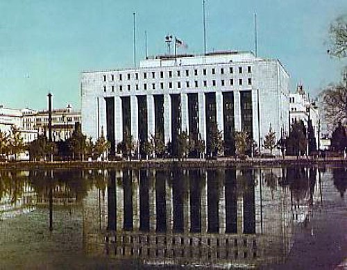
Dai-ichi Life Insurance Building (GHQ SCAP Headquarters)
第一生命館(GHQ総司令部)
The Dai-ichi Life Insurance Building in Tokyo served as General Douglas MacArthur's SCAP headquarters from 1945 to 1952, overseeing the occupation and reconstruction of Japan.

Former Ministry of Finance Building (Current MOF Headquarters)
旧大蔵省庁舎(現財務省本庁舎)
The former Ministry of Finance headquarters in Kasumigaseki, Chiyoda Ward, Tokyo, served as the nerve center of Japan's wartime economic control apparatus. Construction began in 1934 under architect Okuma Yoshikuni of the Ministry of Finance Construction Bureau, but was interrupted by the Second Sino-Japanese War. The building reached provisional completion in 1940 and official completion in 1943. Its robust reinforced concrete structure with protective layers on the roof allowed it to survive the devastating Tokyo air raids of 1945, while many buildings in the area — including the German Embassy in nearby Nagatachō — were destroyed. The surviving exterior walls were retained and incorporated into the postwar restoration. After being requisitioned by GHQ as U.S. military offices and barracks from 1945 to 1955, the building was returned to Japan and underwent extensive renovation through 1963. It remains in active use as the Ministry of Finance and National Tax Agency headquarters, and underwent major base-isolation seismic retrofitting between 2015 and 2020.

Imperial Japanese Naval Academy, Etajima
海軍兵学校
The Imperial Japanese Naval Academy at Etajima, established in 1888, was the primary officer training institution of the Imperial Japanese Navy, comparable to the US Naval Academy at Annapolis.
Themes
View all →Imperial Japanese Navy
大日本帝国海軍
The naval forces of the Empire of Japan, one of the most powerful navies in the Pacific War.
Shipbuilding
造船
Japan's wartime shipbuilding industry and the yards that built the Imperial fleet.
Aviation
航空
Military aviation, aircraft production, and air power in wartime Japan.
Atomic Bombing
原子爆弾投下
The atomic bombings of Hiroshima and Nagasaki in August 1945.
Wartime Government
戦時政府
The political and administrative apparatus that governed Japan during the war.
Heavy Industry
重工業
Steel, munitions, machinery, and industrial production for the war effort.
Strategic Bombing
戦略爆撃
Allied air raids against Japanese cities and industrial targets.
Science & Technology
科学技術
Wartime scientific research, weapons development, and technological programs.
Recently added
RSS →Mobara Naval Airfield Site and No. 3 Aircraft Shelter
茂原海軍航空基地跡・3号掩体壕
A surviving concrete aircraft shelter marks the former Mobara naval airfield. Nearby roads and school sites trace the base's runway, headquarters and barracks within today's city.
Inba Airfield Site and Open-Air Aircraft Revetment
印旛飛行場跡・無蓋掩体壕
An earthen aircraft revetment survives beside a flood-control pond in Inzai. It recalls the Inba pilot-training airfield's wartime conversion to an army fighter base.
Asakawa Underground Aircraft Engine Factory
浅川地下壕(中島飛行機地下工場)
Wartime tunnels beneath the hills near Takao housed a dispersed Nakajima aircraft-engine factory. Part of the surviving I district can be visited through advance-booked preservation-group tours.
Ushio Naval Experimental Station Site
第二海軍技術廠牛尾実験所跡
An unfinished 1945 dispersal site for naval microwave research beside the Oi River. Excavations recorded its electrical facilities before river widening removed the principal foundations.
Seki Underground Factory of Suzuka Naval Arsenal
鈴鹿海軍工廠関防空工場跡(関地下工場)
Sealed tunnel entrances in Kannon-yama recall an underground dispersal factory producing aircraft machine-gun ammunition in 1945. The surrounding park is accessible, but ordinary visits are limited to exterior viewing.
Mitsui Tamano Shipyard (Former Tama Shipyard)
三井造船玉野造船所(旧玉造船所)
A shipbuilding centre founded in 1917 that produced naval vessels and wartime standard merchant ships. Parts of the waterfront remain in industrial use, including modern shipbuilding; unrestricted public entry is not established.
About this atlas
This project maps the real places that played a key role during World War II (1931–1945), recording what each site did in wartime and how it connects to events, institutions and wider themes. It is a place-based resource for research and education, and a practical guide for visiting: add sites to your list and plan a route in one go.